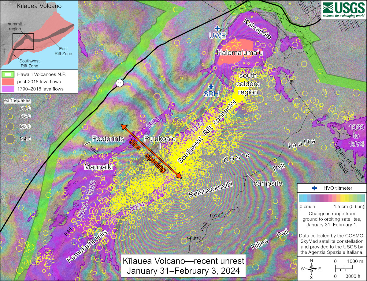
USGS: “This map shows recent unrest at Kīlauea volcano. Yellow circles mark earthquake locations from January 31, 2024, through February 3, 2024, as recorded by HVO seismometers. Colored fringes denote areas of ground deformation over a one-day timeframe from 6 p.m. HST on January 31 through 6 p.m. HST on February 1, 2024. More fringes indicate more deformation. The complex patterns indicate overall deflation of the summit area as magma moved underground to the southwest, where the patterns show uplift and spreading (along with subsidence) due to intrusion of a dike (a vertical sheet of magma).”
(BIVN) – Shortly after the recent magma intrusion at Kīlauea volcano was the topic of a Volcano Watch article, and just before a Magnitude 5.7 earthquake demanded attention, the USGS Hawaiian Volcano Observatory had provided a detailed information statement on the event to the southwest of the summit.
From the February 9 statement by the USGS HVO:
SUMMARY
Kīlauea volcano is not erupting. A magmatic intrusion occurred southwest of Kīlauea’s summit between January 27 and February 3, 2024. Rates of seismicity and ground deformation extending southwest from Kīlauea summit toward the Koa‘e fault system increased significantly and peaked on January 31. More than 700 earthquakes were detected that day, and deformation patterns and ground cracks indicated the emplacement of a dike (a vertical sheet of magma). Rates of seismicity and deformation decreased gradually on February 1-2, and then more significantly on February 3. Seismicity and deformation rates have stabilized as of February 9. The overall decrease in seismicity and deformation suggests that this event is waning. However, renewed episodes of activity remain a possibility and an eruption could occur with little advanced warning. No unusual activity has been noted along Kīlauea’s East Rift Zone.
HVO raised the Volcano Alert Level for Kīlauea from ADVISORY to WATCH, and the Aviation Color Code from YELLOW to ORANGE, at 4:41 a.m. HST on January 31, when there was escalating unrest with increased potential of eruption. HVO lowered the Volcano Alert Level from WATCH to ADVISORY, and the Aviation Color Code from ORANGE to YELLOW, at 8:10 a.m. on February 3, as volcanic activity decreased significantly but continued to be closely monitored for possible renewed increase. Kīlauea remains at ADVISORY/YELLOW at the time of this information statement.
RECENT OBSERVATIONS
The most recent eruption at Kīlauea summit ended on September 16, 2023. Following this eruption, seismicity and ground deformation remained at background levels until October 4-6, 2023, when more than 600 earthquakes and increased rates of ground deformation were recorded south-southwest of Kīlauea summit. Seismicity and inflationary ground deformation throughout the Kīlauea summit region continued intermittently, waxing and waning with days-long periods of increased activity alternating with days-long periods of little or no activity. Periods of increased activity included more than 200 earthquakes per day on October 22, October 26, November 21, December 7, and December 29-30, 2023. The relatively less active periods between these peaks still included 30-50 earthquakes per day.
On January 27, 2024, activity began to increase and more than 250 earthquakes occurred throughout the day. Then on January 31, rates of seismicity and ground deformation increased significantly. HVO raised the Volcano Alert Level for Kīlauea from ADVISORY to WATCH, and the Aviation Color Code from YELLOW to ORANGE, at 4:41 a.m. HST on January 31, in response to escalating unrest with increased potential of eruption. More than 700 earthquakes were recorded on January 31. Earthquake depths remained consistent, 1–4 km (less than 1–2.5 miles) below the surface, and magnitudes ranged from a maximum of just over M3 to less than M1. HVO field crews on the rim of the caldera felt many earthquakes and reported rockfalls in Halema‘uma‘u throughout the morning. Global Positioning System (GPS) instruments southwest of the caldera recorded up to 20 cm (8 inches) of motion. Tiltmeters located near Uēkahuna bluff (summit) and Sand Hill (southwest of the caldera) showed over 60 microradians of change. Satellite data obtained between 6 p.m. HST on January 31 through 6 p.m. HST on February 1 showed complex patterns of ground deformation; overall deflation was observed at the summit, while regions southwest of the summit showed uplift up to about 50 centimeters (20 inches) as well as spreading (along with subsidence). Magma did not reach the surface, although ground cracks associated with ground deformation were later observed by HVO field crews southwest of the caldera.
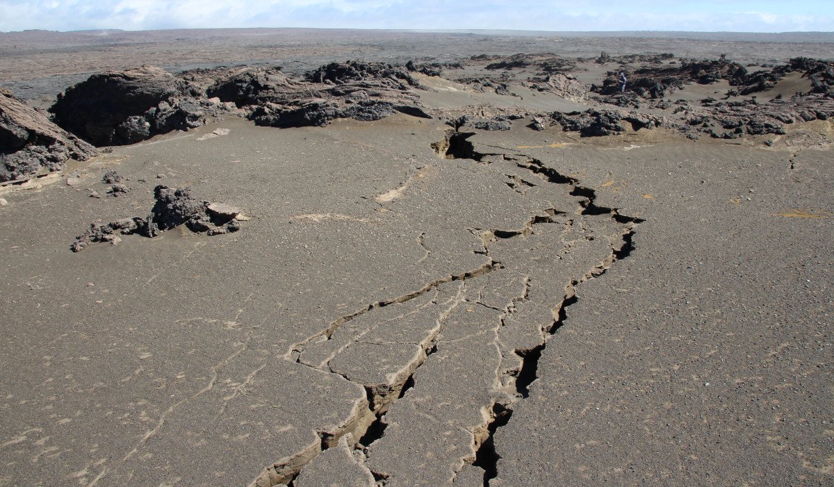
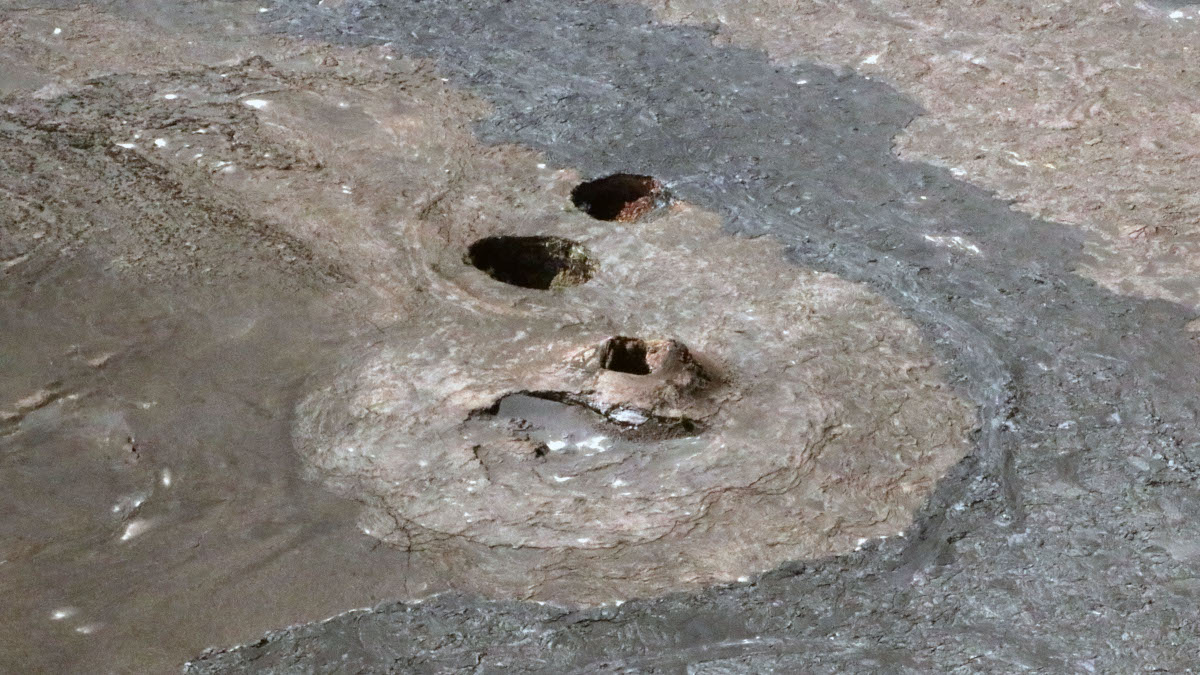
USGS: “On February 3, 2024, a team of HVO scientists documented new ground cracks in three areas of the Maunaiki Trail in the Ka‘ū Desert, caused by the intrusion at Kīlauea south of the summit caldera. These cracks primarily cut the loose Keanakāko‘i tephra which blanketed the region in 1790 CE. Some cracks were over 100 feet (30 meters) long. Note the person for scale in the right upper portion of the photo.” (USGS photo by N. Deligne)
On February 1, activity began to decrease gradually after the peak on January 31, with approximately 650 earthquakes recorded that day. On February 2, approximately 550 earthquakes were recorded. Tiltmeters similarly recorded reduced rates of ground displacement. On February 3, activity decreased significantly, with less than 200 earthquakes throughout the day, and stabilization of surface tilt. HVO lowered the Volcano Alert Level from WATCH to ADVISORY, and the Aviation Color Code from ORANGE to YELLOW, at 8:10 a.m. HST on February 3, as volcanic activity decreased significantly but continued to be closely monitored for possible renewed increase.
As of February 9, seismicity and ground deformation beneath the summit and region extending 8-11 km (5-7 miles) southwest of the caldera under the Koa‘e fault system has stabilized. Earthquake counts are less than 10 events per hour, dispersed widely from the summit to the southwest. Earthquake depths remain consistent at 1–4 km (less than 1–2.5 miles) below the surface and magnitudes range from just over M2 to less than M1. Tiltmeters near Sand Hill and Uēkahuna continue to show low rates of ground deformation.
Sulfur dioxide (SO2) gas emission rates remained low throughout this intrusion. Field measurements indicated an SO2 emission rate of approximately 70 tonnes per day on January 17, 2024, which was similar to measurements in October, November, and early December 2023.
Rates of seismicity and deformation in the upper part of Kīlauea’s East Rift Zone were low to moderate during this event. No significant activity was observed on the middle to lower regions of the East Rift Zone.
INTERPRETATION AND CONTEXT
Patterns of earthquakes and ground deformation indicate that magma intruded beneath the south end of the caldera beginning on the morning of January 27. This activity waxed and waned until January 31 when greatly increased seismicity and ground tilt indicated that a dike (a vertical sheet of magma) was being emplaced, triggering episodic felt earthquakes and rockfalls within Halema‘uma‘u. By 5 p.m. HST on January 31, seismicity migrated southwest of the caldera towards the Koa‘e fault system and tiltmeters at the summit and south caldera area began to record strong deflation. Modeling of tiltmeter, GPS, and satellite radar interferometry (InSAR) data suggest that magma within the initial dike migrated southwest beneath the Koa‘e fault system.
Intrusive activity began in the south caldera region and extended southwest toward the Koa‘e fault system where it intersects the Southwest Rift Zone near Maunaiki. Ground cracks extending tens of meters (yards) in length and centimeters (inches) in width, were observed in the vicinity of Pu‘ukoa‘e and Twin Craters on the eastern edge of the Southwest Rift Zone, suggesting the tip of a dike intruded beneath this area. The cracks primarily cut the loose Keanakāko‘i tephra which blanketed this area of the Kaʻū Desert region in 1790 CE. The connection between the south caldera, the Koa‘e fault system, and the Southwest Rift Zone are not well-understood, but the recent intrusive activity suggests that the area is dynamic and new pathways between these areas can be established.
Numerous intrusions have been recorded in this region in the past, most recently in October and December 2023, in August 2021, and in May 2015. The August 2021 intrusion here occurred over about a week and was followed by an eruption within Halema‘uma‘u about a month later (the eruption that began on September 29, 2021). The May 2015 intrusion here lasted less than a week and occurred during ongoing eruptions within Halema‘uma‘u and at Pu‘u‘ō‘ō. Intrusions also occurred here in the 1960s, 1970s, early 1980s, and in 2006. Only one of these events led directly to a brief eruption in that area; in December 1974, an intrusion began following this path southward, but then erupted for less than 24 hours as a series of short fissure segments with a total length of 5 km (3 miles) as it turned southwest.
WHAT WE ARE DOING
HVO raised the Volcano Alert Level for Kīlauea from ADVISORY to WATCH, and the Aviation Color Code from YELLOW to ORANGE, at 4:41 a.m. HST on January 31 due to the significant escalating unrest with increased potential of eruption. HVO subsequently lowered the Volcano Alert Level from WATCH to ADVISORY, and the Aviation Color Code from ORANGE to YELLOW, at 8:10 a.m. on February 3, as the likelihood of eruption decreased. HVO will re-evaluate alert levels and notices as activity warrants.
HVO continues to closely monitor Kīlauea volcano, watching for any signs of accelerated rates of earthquakes or ground deformation, or signs of shallowing earthquake locations, which usually precede a new outbreak of lava or propagating dike. The overall decrease in seismicity and deformation suggests that this event is waning. However, renewed episodes of activity remain a possibility and an eruption could occur with little advanced warning.
HVO will continue to post daily updates on our website, along with photos, videos, and maps as they become available (here).
HVO is in frequent communication with Hawai‘i Volcanoes National Park and Hawai‘i County Civil Defense. With permission from Hawai‘i Volcanoes National Park, HVO installed two semi-continuous GPS stations on February 2 in order to more comprehensively monitor ground deformation south-southwest of Kīlauea summit.
WHAT WE CAN EXPECT
The overall decrease in seismicity and deformation suggests that this event is waning. However, unrest to the south-southwest of Kīlauea’s summit continues, renewed episodes of heightened unrest remain a possibility, and an eruption could occur with little advance warning. It is unclear how long unrest will continue. It is not possible to say with certainty if current unrest will lead to an eruption. Although it is not possible to forecast an exact outcome, here are three possible scenarios that could play out in the coming days to weeks:
1. Magma continues to accumulate in the region south-southwest of Kīlauea’s summit, but eventually stops with no eruption.
2. Magma continues to accumulate in the Kīlauea summit region, with an eventual eruption inside the caldera, similar to recent eruptions at Halema‘uma‘u. In this scenario, we would expect to see signs of the magma reservoir beneath Halema‘uma‘u re-pressurizing prior to accelerated rates of ground deformation and earthquakes beneath the caldera 1-2 hours before lava reaches the surface.
3. Magma continues to accumulate in the region south-southwest of Kīlauea’s summit, with an eventual eruption outside of the caldera, to the south or southwest. In this scenario, we would expect to see earthquake locations migrating away from the caldera as observed in December 1974, followed by accelerating rates of ground deformation and earthquakes 1-2 hours before lava reaches the surface.

Daisy Hips is a science communicator who brings the wonders of the natural world to readers. Her articles explore breakthroughs in various scientific disciplines, from space exploration to environmental conservation. Daisy is also an advocate for science education and enjoys stargazing in her spare time.