CNN
—
A whirlwind of heavy winter weather is in store Monday as a potent storm brings heavy snowfall and blizzard conditions across the central US and threatens flash flooding, heavy rain and possible tornadoes across the Southeast.
The exceptionally powerful storm is packing nearly every winter weather threat imaginable as it trails from the Southwest to the Northeast through midweek, including strong winds, possible tornadoes, serious flooding, snow and blizzard conditions.
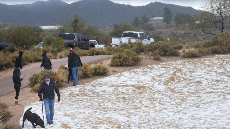
Already, the system is leaving travel woes in its wake. As the storm made its way through the Four Corners region on Sunday, treacherous road conditions and weather-related crashes in Arizona triggered the closure of several portions of I-40, and officials warned against non-essential travel.
The center of the storm still hovered over the Four Corners early Monday, where snowfall was ongoing. The system will strengthen as it moves into the Southern Plains throughout the morning, where ferocious blizzard and whiteout conditions are expected in some areas.
Starting Monday afternoon and into Tuesday, the storm’s impacts will also be felt in the Gulf Coast and Southeast, where nearly 70 million people are at risk for severe weather, including tornadoes, severe wind and flooding rain.
Cities like New Orleans, Louisiana, Gulfport, Mississippi, and Mobile, Alabama, will be impacted as the storm blows through Monday afternoon and overnight, likely whipping up a few tornadoes.
The fast-moving system will cover over 1,800 miles in 72 hours, producing notable snowfall across more than half a dozen states.
The winter weather comes on the heels of another powerful storm that dumped more than a foot of snow over the Northeast over the weekend and brought rain, snow, ice and a tornado as it carved a path from the Gulf Coast to Maine. Snowfall totals reached as high as 18 inches in some areas, including Salem, New Hampshire, and Milton, New York.
The series of storms are contributing to a mounting number of flight delays and cancelations, which have also been caused by the mandatory grounding of certain Boeing jets after a section of one of the planes blew off midair on an Alaska Airlines flight last week.
More than 6,000 flights into, out of, or within the United States were delayed and at least 828 US flights were canceled Sunday, according to tracking website FlightAware.
Some airports have reported significant operational disruptions. Near Hartford, Connecticut, Bradley International Airport, announced 20% of its flights had been canceled Sunday as snow removal operations were underway.
Here’s what to expect in the coming days.
Winter storm alerts stretch over 1,000 miles from Arizona to Wisconsin as the storm carves its path.
Beginning Monday morning, blizzard warnings are in effect and up to a foot of snowfall could be seen in parts of New Mexico, eastern Colorado, the Oklahoma and Texas Panhandles, western Kansas and southwest Nebraska.
The system is expected to rapidly strengthen into an exceptionally powerful January storm and cause widespread, significant effects east of the Rockies.
By Monday afternoon, Louisiana, Mississippi and Alabama will be feeling the force of the storm. Tornadoes are especially likely across the region, and rainfall of 3 to 5 inches could lead to flooding.
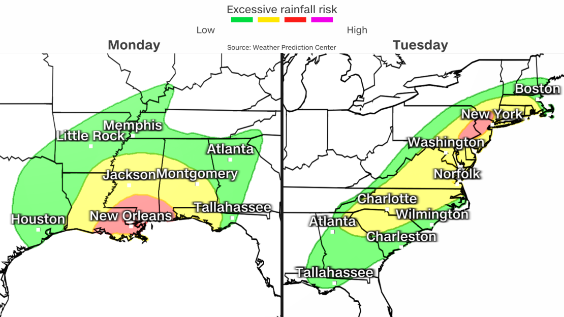
On Tuesday, the same system is forecasted to head further east, where there is an enhanced risk of severe weather for cities like Tallahassee, Florida, Albany, Georgia, and Panama City, Florida, in the early morning and continuing into the afternoon.
Poor visibility and difficult-to-near-impossible driving conditions will set in for the central and southern Plains on Monday and the Midwest on Tuesday. Strong winds will also bring wind chill values below zero degrees for some locations in the Plains.
Heavy snowfall will then spread into the interior Northeast Tuesday afternoon and evening.
Snow and cold temperatures will not be the only concerns as the storm surges northeast, intensifies and expands its reach to much of the eastern half of the US into the middle of the week. Flooding, damaging winds and tornadoes are also a significant threat.
Along the Gulf Coast, warm, moist air will fuel the threat for severe storms, including a few strong tornadoes and damaging winds.
More than 15 million people are under a severe storm threat Monday from Texas to Florida. Over 35 million people are under the same threat level Tuesday from the Panhandle of Florida to the Outer Banks of North Carolina.

An equally serious concern is the potential for significant flooding from the storm’s strong winds blowing water onshore and its potent rainmaking storms. Flood watches are in place across the Southeast on Monday and in the Northeast on Tuesday.
“Widespread and potentially significant river and flash flooding are likely from the central Gulf Coast through much of the Eastern U.S. early this week,” the Weather Prediction Center said. “Powerful onshore winds will lead to widespread coastal flooding along the eastern Gulf Coast and much of the East Coast.”
Widespread rainfall totals of 1 to 3 inches are expected from the Gulf Coast to New England with isolated locations exceeding 4 inches.
There’s serious concern for flooding in the Northeast with this next wave of rain coming right after the first snowstorm dropped more than half a foot of snow in multiple Northeast states.
Heavy rain will accelerate snowmelt and increase the amount of water running off into waterways, raising the ceiling on the flood potential in these areas. As a result, there is a Level 3 out of 4 risk for flooding in portions of New Jersey, New York and Pennsylvania on Tuesday. A Level 2 of 4 threat spans nearly the entire path of the first storm – from Georgia through Massachusetts.
A Level 3 of 4 risk for flooding is also in place along the western coast of Louisiana to the Florida Panhandle for the flood potential from the initial round of rain on Monday.
The rainfall is both a gift and a concern for Louisiana and Mississippi – both still grappling with serious droughts, though drought has already improved substantially since November from a recent overabundance of rain.
Locations along the Gulf Coast from New Orleans to Tallahassee, Florida, are more than 5 inches above normal for rainfall since December 1, so it won’t take much for the saturated ground to flood.
Wind is another concern with saturated ground. It makes trees more vulnerable to toppling over onto power lines or homes. And the winds will be strong enough to cause such damage.
“Gusty winds on the warm side of the storm may exceed 50 MPH and cause damage over the Appalachians to the East Coast,” the Weather Prediction Center said. The center also warned people to “prepare for power outages” from the potentially damaging winds.
The strongest winds will be closer to the coast.
More than 60 million people across the Southern Plains are under high wind alerts and more are likely to continue being added. The National Weather Service office in Boston also noted they might need to issue hurricane-force wind watches – warning of winds akin to a Category 1 hurricane – for coastal areas if the storm’s worst forecast fears came to pass.
Winds will also trigger high surf from 8 to 11 feet and significant beach erosion is possible. Dangerous rip currents are also likely and will continue through at least the middle of the week.
The storm system looks to wrap up near the end of the week, but another storm looks like it could follow a similar path and affect some of the same areas later in the week and into the weekend.
CNN’s Robert Shackelford contributed to this report.

Elaine Hadley is a dedicated journalist covering the ever-evolving landscape of U.S. news. With a keen interest in politics and a commitment to uncovering the truth, she provides insightful commentary and in-depth analysis on domestic issues. When not reporting, Elaine enjoys exploring the diverse cultures and landscapes of the United States.